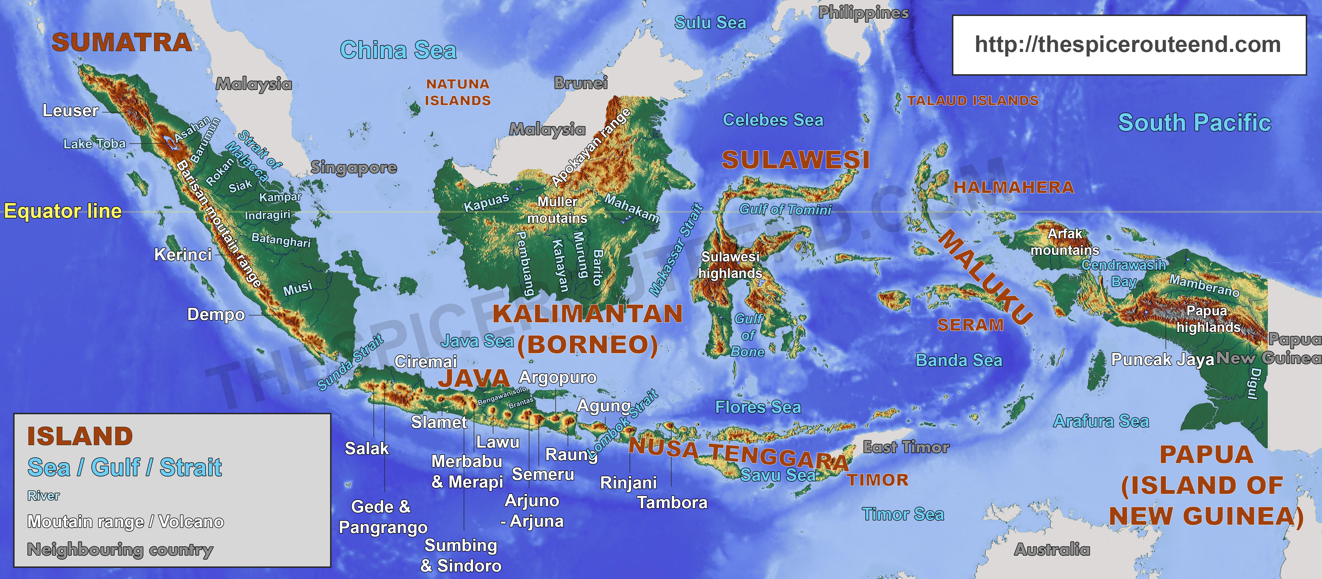
Indonesia : the world largest archipelago
Indonesia is the world largest archipelago situated right on the Equator line, which cuts through the islands of Sumatra, Borneo, Sulawesi and Halmahera.
How many islands does Indonesia own ?
The official number of islands is 17’504 islands but this remained rather hypothetical for a very long time. As of 2004, the Ministry of Home Affairs stated that only 7’870 were actually named, the others lacking both name and even official coordinates.
From 2006, the government has strived for improving this situation. At the 11th United Nations Conference on Standardization of Geographical Names in 2017, Indonesia claimed to have registered 16’056 islands, a net progress from the 13’466 registered as of 2012. This number is expected to keep increasing in the coming years.
About 70% of the islands claimed by the Indonesian government are uninhabited (source).
Indonesia is huge
In songs, Indonesia is often described as spanning from Sabang (the main town of Weh island off Aceh) to Merauke (the last significant town before the border with Papua New Guinea). This is not exactly accurate from a geographical point of view but a pretty good approximation of the reality.
Sabang-Merauke is 5250 km, this is significantly longer than Los Angeles-New York (3950 km) or Gibraltar-Moscow (3800 km).
Consequently, Indonesia uses 3 different time zones :
- GMT +7 for Sumatra, Java and West Kalimantan (dubbed WIB for Waktu Indonesia Barat, this is the standard time of Indonesia)
- GMT +8 for East Kalimantan, Lesser Sunda islands and Sulawesi (dubbed WITA for Waktu Indonesia Tengah)
- GMT +9 for Maluku and Papua (dubbed WIT for Waktu Indonesia Timur)
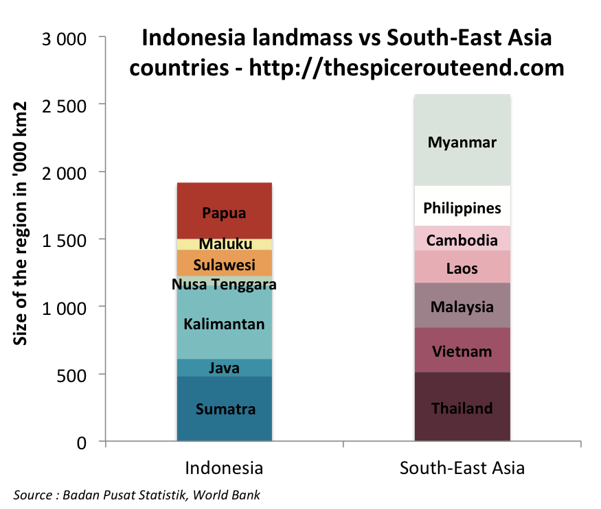
Another way to put the sheer gigantic size of Indonesia is to compare it to its neighbours. If you put aside Myanmar, Indonesia is almost as large as every other South-East Asian countries together :
A world hotspot for volcanic and sismic activities
Indonesia is located on the so-called ‘‘Ring of Fire‘, a zone of intense volcanic activity spanning from New Zealand to Japan and to Chile.
In modern Indonesia, there are 127 active volcanoes and many more dormant ones. Most of the volcanoes are found along the ‘Sunda arc’ (from Sumatra to Flores), the remainings being in the Banda Sea, Halmahera, and North Sulawesi.
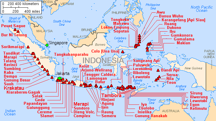
Some eruptions of Indonesian volcanoes have had a world impact :
- The supereruption of the Toba volcano c. 74’000 years ago was probably the largest that ever happened on Earth during the last 25 millions of years. It is possible that this had led to a genetic bottleneck in the world human population. The eruption left a volcanic lake 100×30 km wide (Lake Toba in North Sumatra).
- The eruption of Mount Samalas, near present day Rinjani, in 1257 may have triggered the Little Ice Age.
- The Tambora eruption in 1815 caused 71,000 death among people living nearby and led to what is known as ‘The Year Without Summer’ in the northern hemisphery which caused the worst famine of the century due to a volcanic winter. It is the largest eruption recorded in modern history.
The reason of this volcanic activity is of course geological. Indonesia lies right at the junction of the Eurasian, Australian and Pacific tectonic plates. This results in intense volcanic and sismic activities.
Minor earthquakes occur on a weekly basis in Indonesia (but on various locations). Serious one have proven devastative : Padang 2009 (7,6 SR, 1,115 fatalities), Yogyakarta 2006 (6,4 SR, 5,749 casualties), Aceh 2004 (9,1 SR, 227,898 fatalities)…
For more comprehensive statistics about earthquakes, please refer to the US Geological Survey website.
Indonesia’s demography
The world’s 4th most populous country dominated by Java inhabitants
Indonesia is the 4th most populated country in the world with 255 millions inhabitant in 2015 (based on Badan Pusat Statistik’s data). It is also the country with the largest Muslim population in the world, followed by Pakistan and India.
The demography of Indonesia is quite particular and is shaping the whole political game since the independence. According to the last detailed population information available (the 2010 census), inhabitants of Java islands (Javanese is the main ethnic group of Java but not the only one, the second most important is the Sundanese followed by the Madurese) were 137M compared to a total population of 237M.
Java island accounts for 58% of the population and only 6% of the landmass. If you factor in people who migrated to other islands, the population hailing from Java represents 64% of the total population (figures based on 2010 census, according to 2015 data by BPS Java would now account for 57% of the global population).
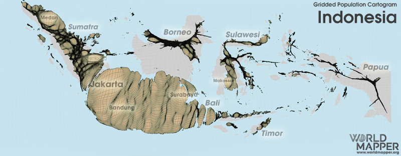
Java is not that big, it spans over 128’000 km2. So it’s roughly the size of Greece (132’000 km2 for 10,75M inhabitants in 2016) or Nicaragua (137’000 km2 for 6,15M inhabitants in 2016). Java has actually a similar profile to Bangladesh with a respective population density of 1070 inhabitants/km2 and 1190 inhabitants/km2.
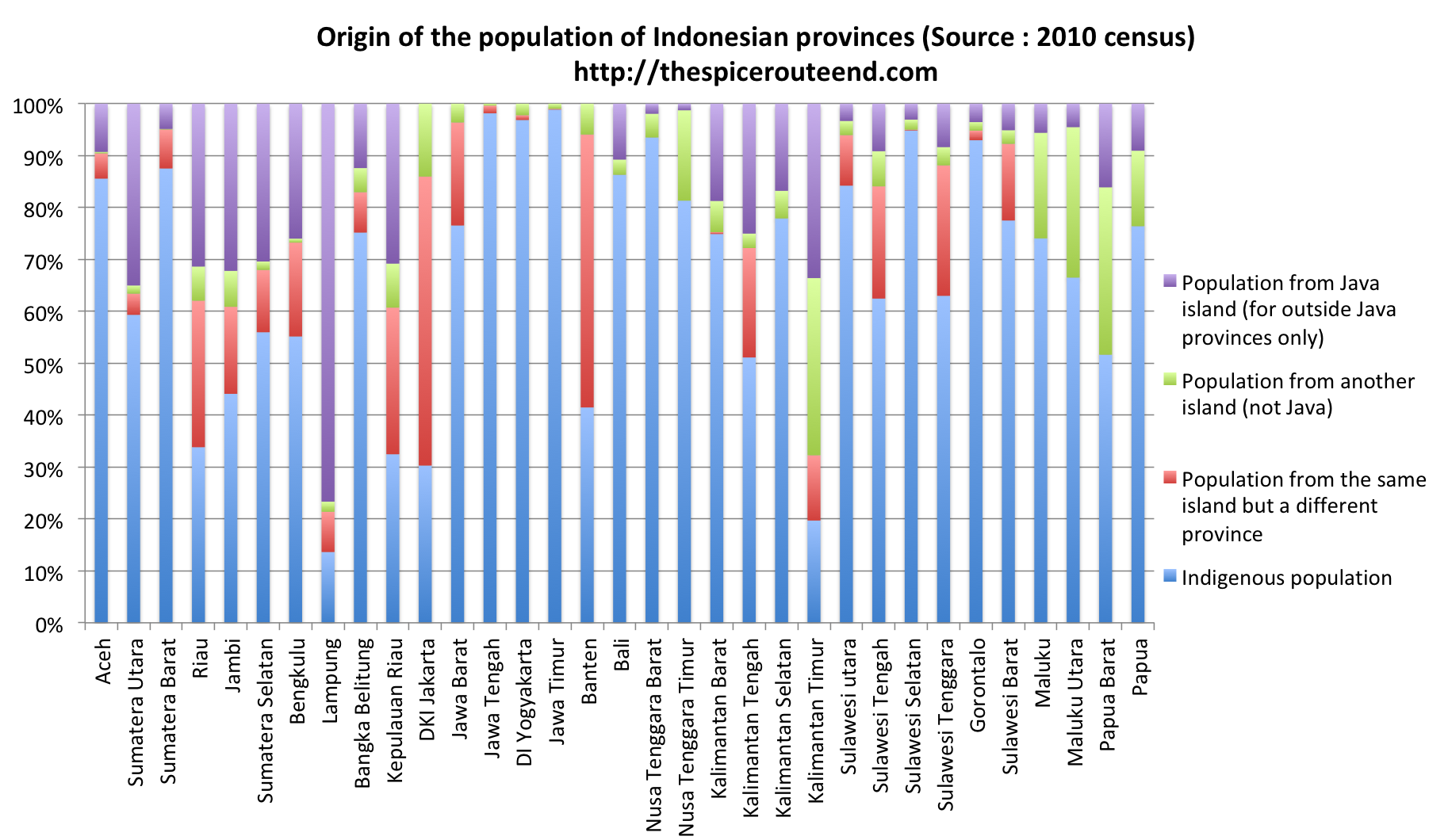
Acknowledging the overpopulation of Java, the government has encouraged since Suharto a transmigration program that has deeply reshaped the local demographics (the following chart is a personal work based on ethnic statistics per provinces, it has its flaws but is helpful to get the big picture) :
A rural country turning increasingly urban
The urban area formed by Jakarta and its surrounding cities (Tangerang, Depok, Bogor and Bekasi) is called Jabodetabek. It’s the second most populated urban area in the world after Tokyo with an estimated 32M inhabitants.
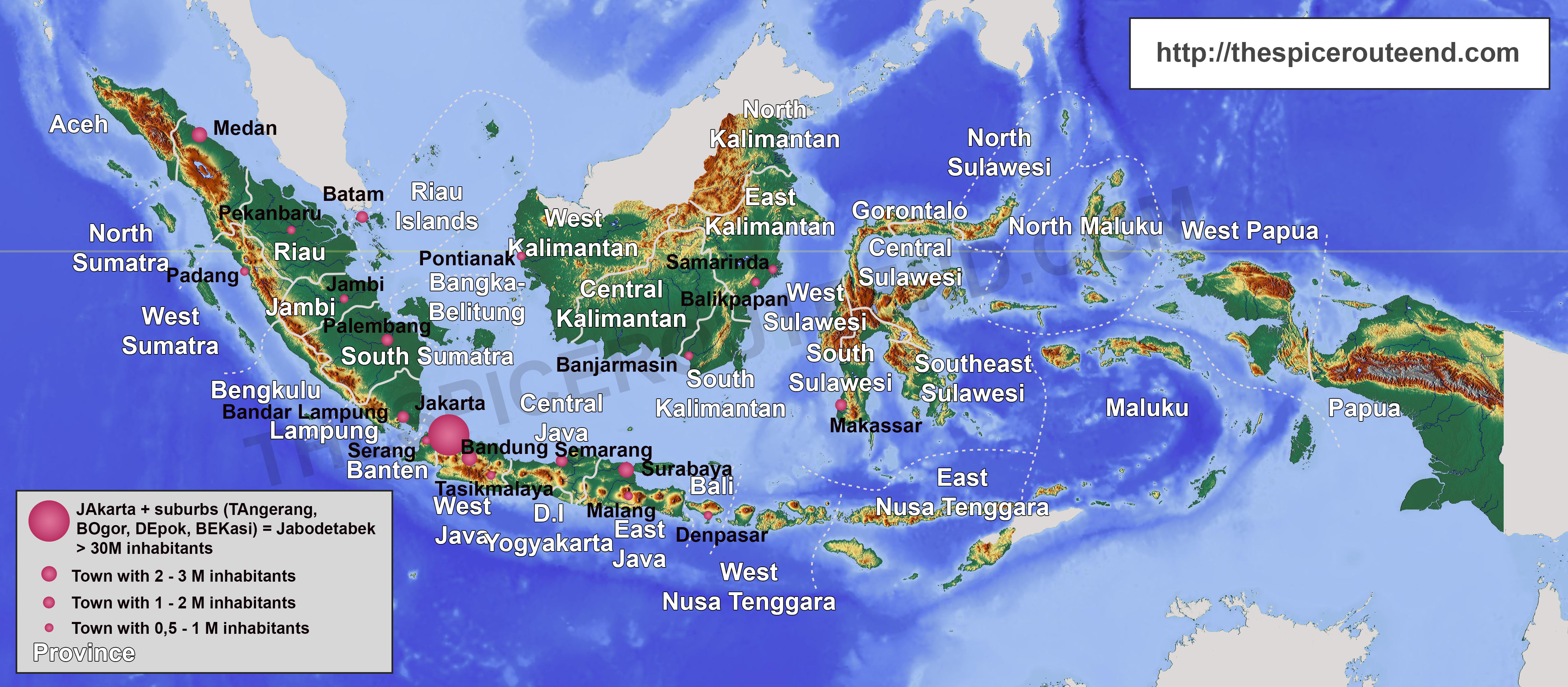
As of 2018, Indonesia is made up of 34 provinces. This number is still evolving, as in 2012 the province of North Kalimatan has been splitted from East Kalimantan and West Sulawesi from South Sulawesi.
In 2015, half of Indonesia population is still rural, with significant regional differences though (source : BPS).
Sources
- Indonesian population : 2010 Population Census, Indonesia Population Project 2010-2035 by the National Statistic Agency (BPS)
- Other countries data : World Bank.
Leave a Reply